James Hutton's Slighouses
Remnants of an Eighteenth Century Landscape
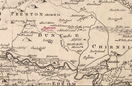
James Hutton, the founder of modern geology, farmed in Berwickshire from 1754 to 1768. His farm Slighhouses (GR NT822593), is located in the lower margins of the Lammermuir Hills in north-eastern Berwickshire, with Bonkyl Edge immediately northwards and the expansive views southwards to the Cheviot Hills in Northumberland.
It is a gently undulating open landscape characterised today by a pattern of large, regular, predominantly arable fields, defined by hedgerows, wire fences and occasional walls. Dispersed conifer and mixed woodland punctuates the landscape in areas of rough or wet ground mostly adjacent to running water. The Marygold Plantation on Bonkyl (Buncle) Edge is an especially predominant feature.
In the middle of the eighteenth century however, the locality will have been very open, with no enclosures, uncultivated and farmed by the runrig or open-field system for sheep. It will have been characterised by extensive marsh on low ground and whin or gorse scrub on higher ground. Hutton described it as a “cursed country” and “… destitute of wood”. Other contemporary descriptions confirm this view.